Monday 31 July 2017

St Martin's Island is in Bangladesh

St Martin's is a tropical cliché and the only coral island in Bangladesh, with beaches fringed with coconut palms and laid-back locals. It's a clean and peaceful place with nothing more strenuous to do than soak up the rays — even mosquitoes are a rarity. There's a naval base near the centre of the island, and the USA looked into setting up one of their own a few years back. The island was devastated by a cyclone in 1991 but has fully recovered, and was untouched by the 2004 tsunami.
It is possible to walk around St Martin's in a day since it measures only 8 km², shrinking to about 5 km² during high tide. Most of the island's 7000 inhabitants live primarily from fishing, and between October and April fishermen from neighbouring areas bring their catch to the island's temporary wholesale market. Rice and coconuts are the other staple crops, and algae is collected and dried from the sea rocks and sold for consumption to Myanmar.
Most things are concentrated around the far north of the island, with the centre and south being mostly farmland and makeshift huts. There is no electricity on the island, though the larger hotels run generators in the evenings for a few hours.
November to February is the main tourist season with the best weather, though keep an eye on the forecast, as the occasional cyclone can strike during this time.
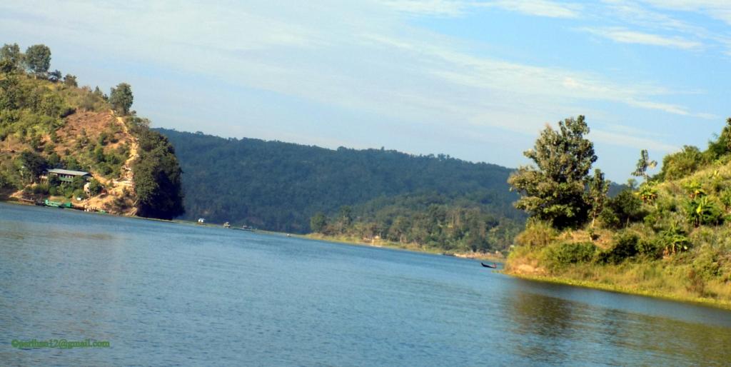
From Teknaf you can cruise to St Martin's Island with the best and the safest ship Keari Sindbad and reach St Martin's comfortably in 2 or fewer hours. Keari Sindbad cruise journey is a pleasant one as you will see the spectacular views of Teknaf's hill on one side and Mayanmar on the other side while it cruises along the Naf River.


Ferries leave the island around 3pm.Keari Sindbad ferry and you can purchase a round trip ticket; which can same day return or 1-2 days later. Prices are same whenever you return. The return fare on Keari Sindbad start from BDT 550-800 as of September 2014.


Sunday 30 July 2017

Mahasthangarh (Bengali: মহাস্থানগড় Môhasthangôṛ)

Mahasthangarh (Bengaliমহাস্থানগড় Môhasthangôṛ) is one of the earliest urban archaeological sites so far discovered in Bangladesh. The village Mahasthan in Shibganj thana of Bogra District contains the remains of an ancient city which was called Pundranagara or Paundravardhanapura in the territory of Pundravardhana.A limestone slab bearing six lines in Prakrit in Brahmi script, discovered in 1931, dates Mahasthangarh to at least the 3rd century BC.  The fortified area was in use until the 18th century AD.
Together with the ancient and medieval ruins, the mazhar (holy tomb) of Shah Sultan Balkhi Mahisawar built at the site of a Hindu temple is located at Mahasthangarh. He was a dervish (holy person devoted to Islam) of royal lineage who came to the Mahasthangarh area, with the objective of spreading Islam among non-Muslims. He converted the people of the area to Islam and settled there.
Discovery.
Several personalities contributed to the discovery and identification of the ruins at Mahasthangarh. Francis Buchanan Hamilton was the first to locate and visit Mahasthangarh in 1808, C.J.O'Donnell, E.V.Westmacott, and Beveridge followed. Alexander Cunningham was the first to identify the place as the capital of Pundravardhana. He visited the site in 1879
Geography.
Mahasthangarh, the ancient capital of Pundravardhana is located 11 km (6.8 mi) north of Bogra on the Bogra-Rangpur highway, with a feeder road (running along the eastern side of the ramparts of the citadel for 1.5 km) leading to Jahajghata and site museum. Buses are available for Bogra from Dhaka and take 4½ hours for the journey via Bangabandhu Jamuna Bridge across the Jamuna River. Buses are available from Bogra to Mahasthangarh. Rickshaws are available for local movement. Hired transport is available at Dhaka/ Bogra. Accommodation is available at Bogra. When travelling in a hired car, one can return to Dhaka the same day, unless somebody has a plan to visit Somapura Mahavihara at Paharpur in the district of Naogaon and other places, or engage in a detailed study.
It is believed that the location for the city in the area was decided upon because it is one of the highest areas in Bangladesh. The land in the region is almost 36 metres (118 ft) above sea level, whereas Dhaka, the capital of Bangladesh, is around 6 metres (20 ft) above sea level. Another reason for choosing this place was the position and size of the Karatoya, which as recently as in the 13th century was three times wider than Ganges.
Mahasthangarh stands on the red soil of the Barind Tract which is slightly elevated within the largely alluvium area. The elevation of 15 to 25 metres above the surrounding areas makes it a relatively flood free physiographic unit.


Mainamati of BD

Mainamati (Bengaliময়নামতি Môynamoti) is an isolated low, dimpled range of hills, dotted with more than 50 ancient Buddhistsettlements dating to between the 8th and 12th century CE. It extends through the centre of the district of Comilla in Bangladesh. Mainamati is located almost 8 miles from the town of Comilla. It is the home of one of the most important Buddhist archaeological sitesin the region. Comilla Cantonment is located nearby and houses a beautiful colonial era cemetery.
[1] Mainamati is named for the Chandra queen of the same name, mother of Govindachandra. Mainamati is only 114 km. from Dhaka city and is just a day's trip by road on way to Chittagong.

Shalban vihara: The centre piece of the Buddhist sites at Mainamati is the Shalban vihara, almost in the middle of the Mainamati-Lalmai hill range consists of 115 cells, built around a spacious courtyard with a cruciform temple in the centre, facing its only gateway complex to the north, resembling that of the Sompur Bihara. It is clearly a Vihara, or an educational centre with residential facilities.

Kutila Mura: situated on a flattened hillock, about 5 km north of Shalban Vihara inside the Comilla Cantonment is a picturesque Buddhist establishment. Here, three stupas are found side by side representing the Buddhist "Trinity" or three jewels, i.e. the BuddhaDharma and Sangha.

Charpatra Mura: is an isolated small oblong shrine situated about 2.5 km. north-west of Kotila Mura stupas. The only approach to the shrine is from the East through a gateway which leads to a spacious hall. Here a number of shrines can be found.
Ananda Rajer Badi

Mainamati Ranir Badi: The Mainamati site Museum, situated next to Shavian Vihara, houses a good collection of artifacts found at these sites. The Museum has a rich and varied collection of copper plates, gold and silver coins and 86 bronze objects. Over 150 bronze statues have been recovered mostly from the monastic cells, bronze stupas, stone sculptures and hundreds of terracotta plaques each measuring on an average of 9" high and 8" to 12" wide.


Saturday 29 July 2017

অবিকল সুন্দরবন


 এক নদ, এক নদী আর সাগরের মোহনার বুকে ফাতরার বন এই বন থেকে শুরু হয়েছে বরগুনা জেলা
বনে যেতে হবে নৌকায় করে ছোট নৌকায় প্রমত্ত আন্ধারমানিক-খাপড়াভাঙা পাড়ি দিতে হবেভাবতেই কাঁপন ধরে যায় তবে বনের রূপের টানে না যাওয়াটাও সায় দেয়নি আমাকে আমরা সাতজন প্রমত্ত নদ-নদী পাড়ি দিয়ে ঢুকলাম ফাতরার বনে বনের যতই কাছে যাই, অবাক হওয়ার মাত্রা ততটাই বাড়তে থাকে সুন্দরী, গরান, বাইন, গোলপাতা, পশুর, গেওয়া, করমচাকী নেই? সুন্দরবনের সব গাছ ডালপালা মেলে আছে ফাতরার বনের চারপাশে ছোট ছোট খাল বনের বুকটাকে চিড়ে দিয়ে গেছে মাছ ধরার নৌকা থেকে জেলেরাও জাল ছড়িয়ে রেখেছেন সেখানে নানা প্রজাতির চিংড়ি, পোয়া, তপসে, কোরাল, পারশে, রূপচাঁদা ইলিশ মাছের স্বাদ এখান থেকেই মেলে আর সুস্বাদু কাঁকড়া তো আছেই বনের ভেতরে যেতে হলে সুন্দরবনের মতো শ্বাসমূলের (হুল) ফাঁকে ফাঁকে পা দিয়ে চলতে হয় খানিকটা দুর্গম পথ পাড়ি দিয়ে আমরা সবাই গেলাম ফাতরার বনে পশ্চিম-দক্ষিণ প্রান্তে; যেখানে সাগরের সঙ্গে মিশে একাকার হয়ে গেছে আন্ধারমানিক নদ আর খাপড়াভাঙা নদী মোহনার পাড়ে দাঁড়াতে না দাঁড়াতেই শুদ্ধ বাতাস, আছড়ে পড়া ঢেউ পা দুটি ভিজিয়ে দিতে লাগল বিরামহীনভাবে সূর্য যতই সন্ধ্যাবেলাকে কাছে টানছে, জোয়ারের পানি ততটাই বাড়ছিল এই মোহনায় বিট কর্মকর্তা জাফর উল্লাহ আর শংকর দা বললেন, ফাতরার বন আসলে সুন্দরবনের একটি অংশ ছিল মানুষের চাপ-প্রতাপে বন থেকে বেঙ্গল টাইগার-হরিণ হারিয়ে গেছে তবে বানর, শূকর, শজারু, মেছো বাঘ, শিয়াল, অজগরসহ সব ধরনের সাপ, বনমোরগের বসতি আছে এখানে


কুয়াকাটা ভ্রমণে গেলে পর্যটকেরা সহজেই ঘুরে আসতে পারেন ফাতরার বন ট্রলার ভাড়া করে যেতে ঘণ্টা দুয়েক সময় লাগে বন বিভাগের কাছ থেকে অনুমোদন নিয়ে বনভোজনের ব্যবস্থা আছে বনের ভেতরেমায়ের দোয়ানামে একটি ছোট খাবারের হোটেল রয়েছে, যেখানে পাওয়া যায় কাঁকড়া ভাজা, মাছ-চিংড়ি ভাজা বনের ভেতরে মজাদার খাবার খেতে ভয় নেই কারণ বাঘ তো হারিয়ে গেছে ফাতরার বনে তবে বাঘ ফিরে আসুক এখানে, সেটা সবারই প্রত্যাশা তাহলে বাঘের ভয়ে রক্ষা পাবে ফাতরার বন


যেভাবে যাবেন
ফাতরার চরে যেতে হলে প্রথমে আসতে হবে কুয়াকাটায় সেখান থেকে ইঞ্জিনচালিত নৌকায় এক ঘণ্টায় যাওয়া যায় ফাতরার চরে ঢাকা থেকে কুয়াকাটায় সড়ক নৌদুই পথেই যেতে পারবেন তবে লঞ্চ আসে পটুয়াখালী পর্যন্ত লঞ্চে সিঙ্গেল কেবিনের ভাড়া হাজার টাকা, ডবল কেবিনের ভাড়া হাজার ৮০০ টাকা ভিআইপি কেবিন ভাড়া হাজার টাকা পটুয়াখালী থেকে বাস অথবা মাইক্রোবাসে যাওয়া যাবে কুয়াকাটায় বাসভাড়া জনপ্রতি ১০০ টাকা মাইক্রোবাসের ভাড়া দরদাম করে নিতে হবে

ঢাকা থেকে কুয়াকাটায় বাসে যাওয়া যায় চেয়ারকোচে জনপ্রতি ভাড়া ৬৫০ টাকা শীতাতপ নিয়ন্ত্রিত কনক পরিবহনের ভাড়া হাজার ৩০০ টাকা কুয়াকাটা থেকে ফাতরার চরে যাওয়ার জন্য ইঞ্জিনচালিত বোট হাজার থেকে হাজার ৫০০ টাকায় পাওয়া যায় ফাতরার চরে যাওয়ার আগে বন বিভাগ থেকে অনুমতি নিতে হবে

Friday 28 July 2017

কাপ্তাই বাঁধ

কাপ্তাই বাঁধ
কর্ণফুলি পানি বিদ্যুৎ কেন্দ্র
পাকিস্তান সরকার ১৯৫৬ সালে আমেরিকার অর্থায়নে কাপ্তাই বাঁধ নির্মাণ শুরু করে ১৯৬২ সালে এর নির্মাণ শেষ হয় ইন্টারন্যাশনাল ইঞ্জিনিয়ারিং কোম্পানি এবং ইউতাহ ইন্টারন্যাশনাল ইনকর্পোরেট ৬৭০. মিটার দীর্ঘ ৫৪. মিটার উচ্চতার বাঁধটি নির্মাণ করে বাঁধের পাশে ১৬টি জলকপাট সংযুক্ত ৭৪৫ ফুট দীর্ঘ একটি পানি নির্গমন পথ বা স্প্রিলওয়ে রাখা হয়েছে স্প্রিলওয়ে প্রতি সেকেন্ডে লাখ ২৫ হাজার কিউসেক ফিট পানি নির্গমন করতে পারে প্রকল্পের জন্য তখন প্রায় ২৫ কোটি ৪০ লাখ টাকা বাজেট নির্ধারণ করা হলেও পরে তা ৪৮ কোটি ছাড়িয়ে যায়
অধিভুক্ত এলাকা
কাপ্তাই হ্রদের কারণে ৫৪ হাজার একর কৃষি জমি ডুবে যায় যা এলাকার মোট কৃষি জমির ৪০ শতাংশ এছাড়া সরকারি সংরক্ষিত বনের ২৯ বর্গমাইল এলাকা অশ্রেণীভুক্ত ২৩৪ বর্গমাইল বনাঞ্চলও ডুবে যায় প্রায় ১৮ হাজার পরিবারের মোট এক লাখ মানুষ বাস্তুচ্যূত হয়
বিদ্যুৎ উৎপাদন
প্রথমে এই কেন্দ্রের বিদ্যুৎ উৎপাদন ক্ষমতা ধরা হয়েছিল লাখ ২০ হাজার কিলোওয়াট প্রথমে ৪০ মেগাওয়াট ক্ষমতা সম্পন্ন নম্বর ইউনিট স্থাপন করা হলেও পরে ১৯৬৯ সালের ৫০ মেগাওয়াট ক্ষমতা সম্পন্ন নম্বর ইউনিটের কাজ শুরু হয় বর্তমানে মোট পাঁচটি ইউনিট চালু আছে যার মোট বিদ্যুৎ উৎপাদন ক্ষমতা ২৩০ মেগাওয়াট
পর্যটন
কাপ্তাই হ্রদের ঝুলন্ত ব্রীজ
কাপ্তাই লেককে ঘিরেই মূলত রাঙামাটি জেলার পর্যটন শিল্প গড়ে উঠেছে এই লেকের উপর রয়েছে বিখ্যাত ঝুলন্ত ব্রীজ লেকের দুই ধারই পাহাড়-টিলা দিয়ে ঘেরা ট্রলার ভাড়া করে লেকে ভ্রমণ করা যায় ট্রলারে করে যাওয়া যায় শুভলং জলপ্রাপাতে লেকের পাড়ে রয়েছে নতুন চাকমা রাজবাড়ি বৌদ্ধ মন্দির পুরাতন চাকমা রাজবাড়ি কাপ্তাই বাঁধ নির্মানের সময় লেকে তলিয়ে যায় রাজবন বিহার বাংলাদেশে বৌদ্ধ সম্প্রদায়ের বৃহত্তম বিহার রাঙামাটি শহরের অদূরেই অবস্থিত, যা পূণার্থী এবং দর্শনার্থীদের অন্যতম আর্কষনীয় স্থান


কীভাবে যাবেন?
ঢাকা থেকে কাপ্তাই যাওয়ার সরাসরি বাস রয়েছে কায়াক ক্লাবে কায়াকিং করতে ঘণ্টায় লাগবে ৩০০ টাকা উল্লেখ্য, ফেসবুকে কায়াক ক্লাবের পেইজে আগে থেকে যোগাযোগ করে যাওয়া ভালো কারণ, আবহাওয়া বা অন্যান্য বিশেষ কারণে কায়াকিং বন্ধ থাকতে পারে কায়াকিং করা যায় সন্ধ্যা পর্যন্ত সেখান থেকে সিএনজিচালিত অটোরিকশায় জনপ্রতি ১৫ টাকা নেবে শেখ রাসেল ইকোপার্কে যেতে কেব্ কারে জনপ্রতি ২৩০ টাকা লাগবে


Happy Friendship Day

Happy Friendship Day. Wish you all of my friends in the World. Facebook